a short picture gallery of other
images of Aylestone, Leicestershire.
1. 2.
2. 3.
3.
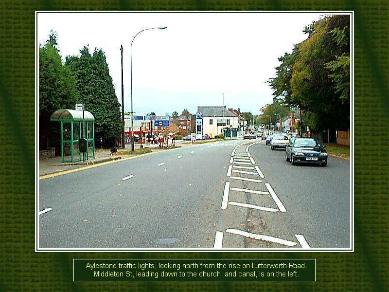
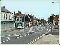
1. Three views of the main crossroads in
Aylestone,
where Middleton Street, to the left, dips down past the church to the
river and canal and onto the Braunstone Lane that leads to that village
a mile or two away across the river meadows. Wigston Lane, with the
Rutland Hotel on the corner (seen clearer on pic 3), climbs up steeply
to the right before dropping again to meet with Saffron Lane before
going on to Wigston itself.
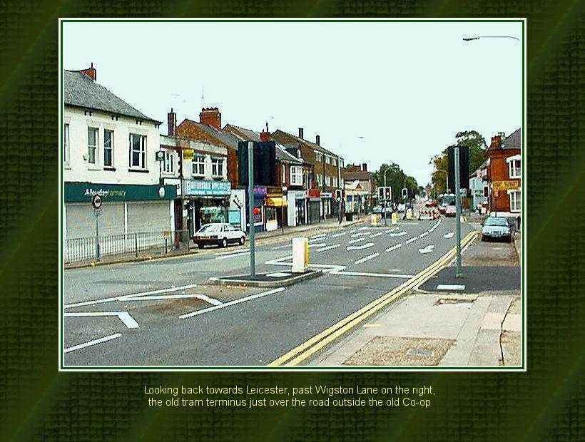
2. From opposite the top of Middleton Street,
we can
see past the shops and old tram terminus back up the long straight of
Aylestone Road and into Leicester.
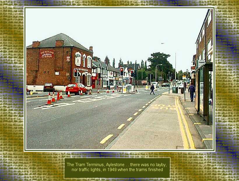
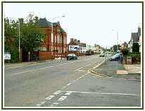
3. And looking back the other way, from the
tram
terminus itself and back up the Lutterworth Road, that also climbs a
good way almost parallel to both the river and canal before dropping
down to cross both of them just before Blaby.
4. 5.
5. 6.
6.
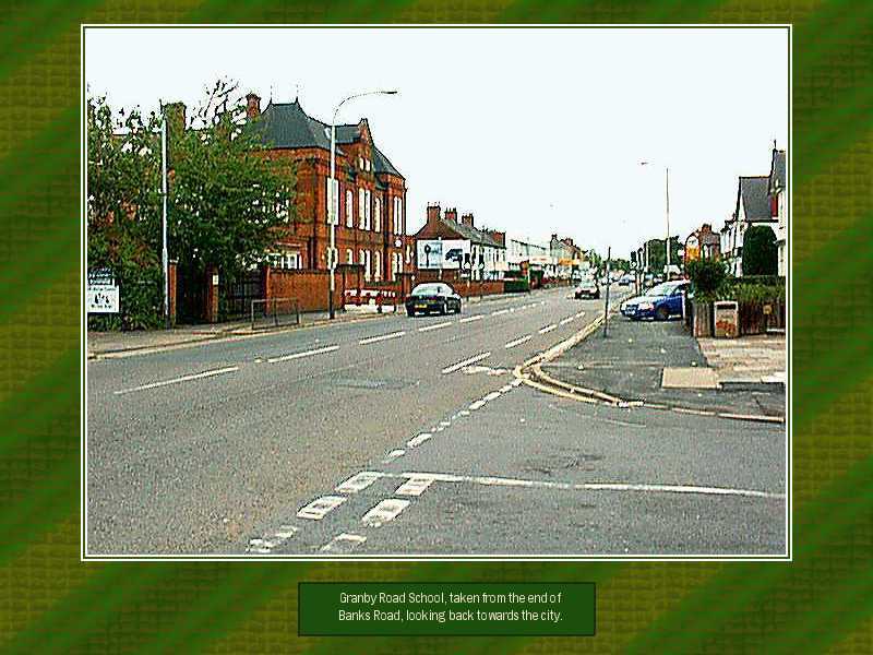
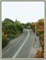
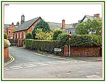
4. Granby Road School, just about 700 yards
back
towards the city, belies its size and depth in this view, shielded as
it is by trees. Aeons of Aylestone folk must have attended here over
the years, and many will recall when the most frequent vehicle down
here was a tram ! It might look quiet here, but it's a dangerous road,
nonetheless, as many local families can tragically long testify.
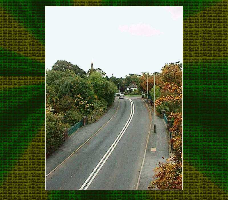
5. The view from the famous Great Central
Railway ..
now a nearly-as-famous extended dog toilet . . looking east over the
bridges over the River Soar, and canal. The steeple of the 13th century
St Andrew's Church peeps shyly now over the trees, though this view
used to be much more open until recent years. It used to be possible to
see further into the village from here, as well as the steeple and a
good bit of the tower. The walk along the railway embankment, marked
out, tarmacced, easy access up frequent sets of steps as it passes
through the village, and with plenty of seats, etc . . it could be
lovely . . but .. uugghh! Watch where you walk . . You know what I mean
. . Brown Snow !! The next picture is in Narrow Lane, just over that
second bridge and turn right directly opposite the church.
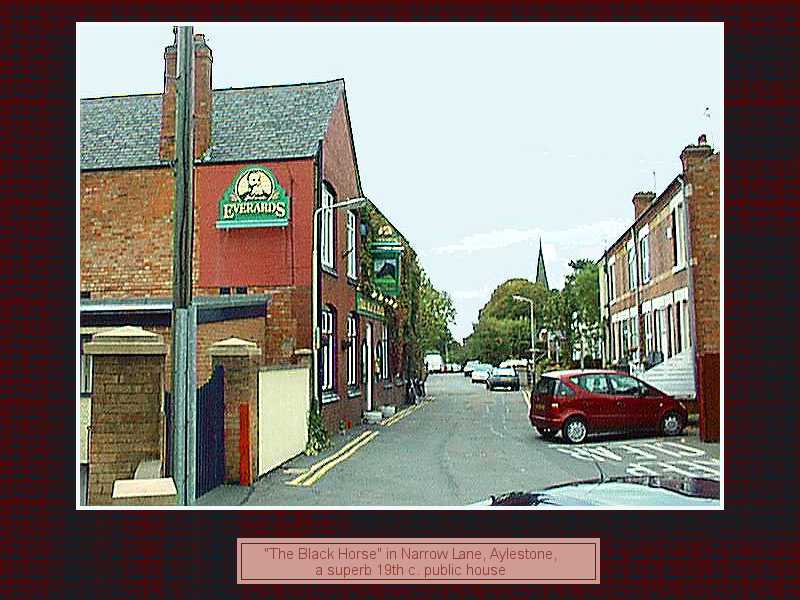
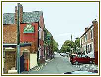
6. Ah, the old Black Horse, just up Narrow
Lane . . she
ain't what she used to be . . when she was our favourite local before
we left Leicestershire, this establishment was one of the four main
drinking establishments in the village; two other pubs, the Union Inn
and Rutland Arms, and the Working Men's Club, are all happily still
open. Now, it appears that The Black Horse is in the "Good Pub Guide"
as one of their favoured establishments in the area . . there's a link
at the bottom of this page. There wasn't a "Good Pub Guide" when I
lived there . . and there were very few good pubs, but thankfully, this
was one of them. It still retains much of its old charm, and we feel
would be recognisable to any of our ancient relatives if they could
step through the door. And they do keep a nice pint . .
7. 8.
8.
9. 10.
10.
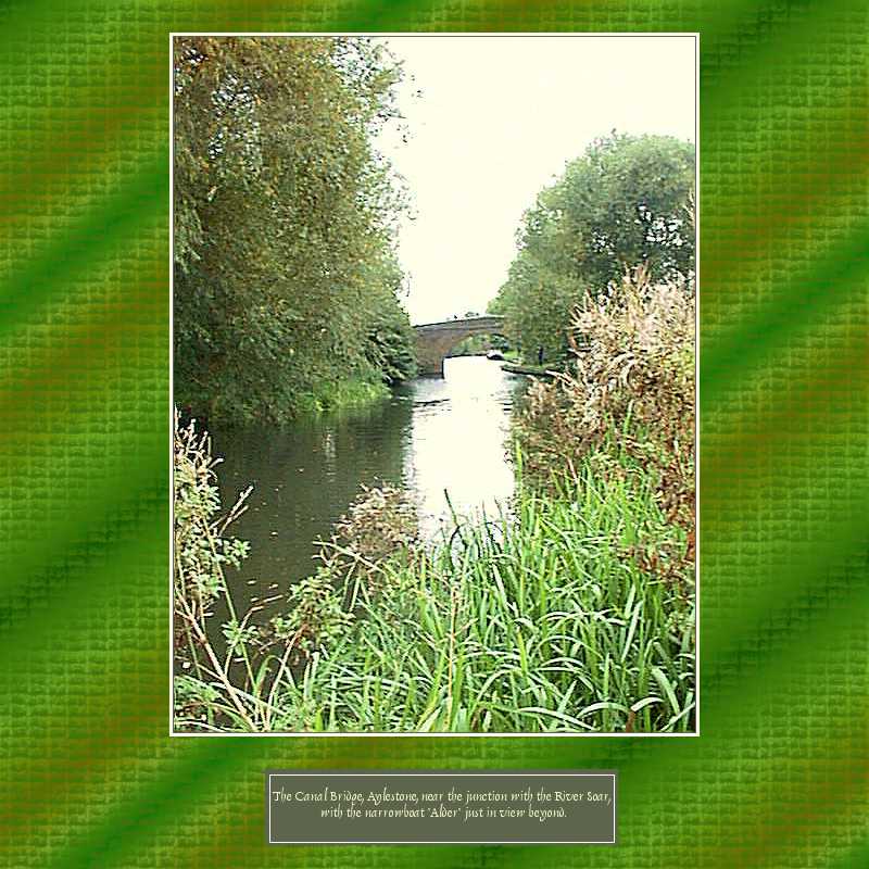
And so to the river and canal. It's only when
preparing
these last few pics I became aware of two things. Firstly, how
difficult it is to capture the escence of Aylestone . . I haven't got
it, nothing like. These pics will mean something to those who know the
place, but they still don't capture it, don't do it justice. And
secondly, the amount of green growth, especially here down by the
water, is many, many times what it was only 20 years ago. The trees are
massive, the railway embankment grown over to be almost wooded in a way
it never could have been in railway days, similarly with stretches of
the canal itself as shown here, and the views over the river meadows to
Braunstone completely obscured by bushes and hedgerows. Maybe this is
how it once was down here 60 years ago, and it's only now just growing
back. But I have the feeling that land management, grazing of pasture,
use of footpaths, made for a much more open landscape than we see now.
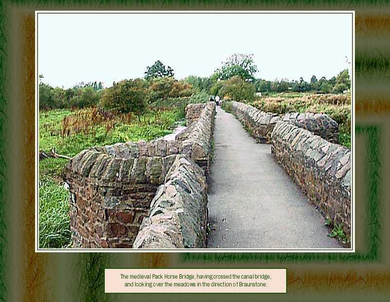
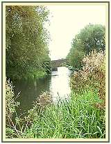
Aylestone's historic glory is the medieval
Pack Horse
Bridge, dating from 1400-and-something, to take the local 'road' across
the flood meadows to the west to Braunstone, the next parish in that
direction. It's even longer than shown here, for there's another
sizeable section a few hundred yards beyond those trees in the next
hedgerow. How much history has passed this way, how many Plantagenet
knights crossed the flood meadows of the Soar here, I wonder. Did some
of the defeated of Bosworth perhaps pass this way, trying to get into
Leicester undiscovered for shelter and succour ? Tudor dissolutionists,
Civil War participants, all passed by here, or not so far away. Prince
Rupert brought a great army when he besieged the Parliamentarians then
holding Leicester; he bombarded the New Workes from the Raw Dykes, only
a mile or so down the river from here. Did his army encamp around here
. . . ? Georgians, Jacobites, and more lately, the ordiliness of the
Victorians, all had an influence on these meadows and the village that
grew slowly nearby.
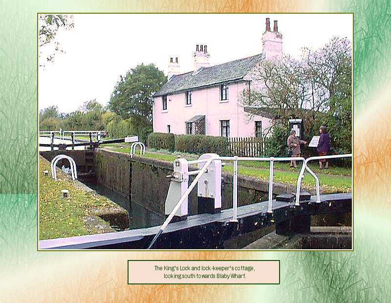
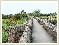
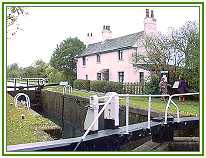
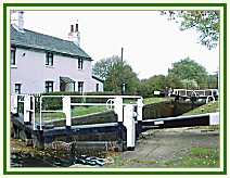
The next two pictures are of the latter eras,
the canal
age that tamed the river and connected London with the great resources
of coal, brick and cloth in the Midlands. Pics 9 and 10 are the 'King's
Lock', by bridge no. 104, now lovingly restored and enhanced by the
rural idyll of the lock-keeper's cottage. The towpaths are maintained,
frequented not only by walkers, but cyclists, runners, and of course,
fishermen, to such a standard that it is now possible to walk right
into Leicester. Full of rural charm now, but a different scene not that
long ago when this lock would have been a hive of activity as boats of
cargo passed in either direction, most towed by by that most-missed of
farming and industrial assets, the heavy horse. If walking the railway
track is a bit messy now, that must be nothing to what it must have
been like trying to traverse the towpath . . very risky, especially if
you slipped !!
11.
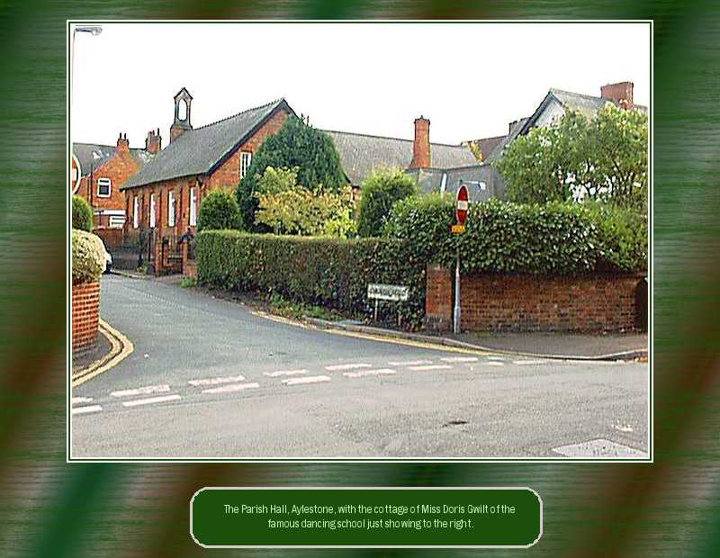
Lastly in this collection, standing almost
opposite the
Rectory on Old Church Street, we can look up Church Street and see one
end of the Parish Hall, which looks as if it may have been the original
Aylestone School long before the days of Granby Road. To the right,
behind the tree, is the white painted cottage that used to belong to
Miss Doris Gwilt, famous in Aylestone from the 1950's right through to
the present day for her dancing school. Several hundreds of girls, and
not a few boys, passed through Miss Doris' Dancing School on their way
out to the wider world, many becoming professional dancers.
(see the link below for more Aylestone images on a superb
Great
Central Railway site,
tracing the course of the railway right through Leicester ! Excellent
!!)
.
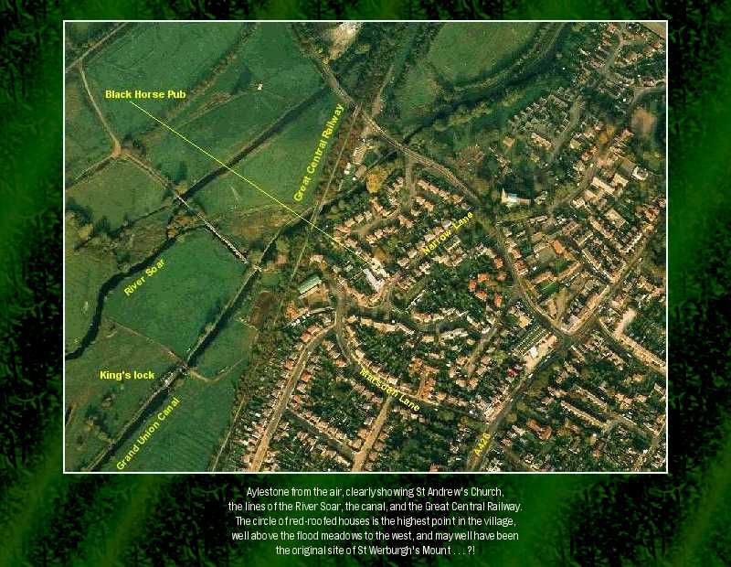
12.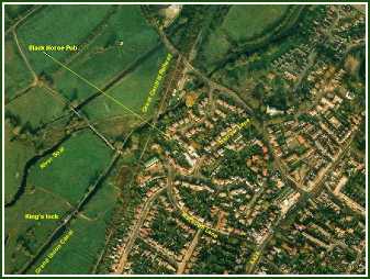
Aylestone from the air . . taken one bright
summer's
morning before the lark was up, I should think. The roof of the nave of
St Andrew's Church gleams in the sun, and the line of the Pack Horse
Bridge is clearly visible as it first crosses the canal and then the
river.
The 1881 census talks of some addresses in
Aylestone
being in "St Werburgh's Mount" . . there's no road or lane of that name
now. Could this be the small knoll or rise almost opposite the church
and Union Inn, just to the right of centre, where that cluster of
red-roofed houses are now ?
I've since found out that St
Werburgh was an ancient Anglo-Saxon
princess, circa 500-700 time. She was obviously well-known around these
parts, but what connection if any did she have with Leicester, or Ratae
Coritanorum as it was known then. I wouldn't know, I wasn't around then
. .. :-)
I hope you have enjoyed this brief visit to
Aylestone,
whether old resident long since moved away, or someone who is still
familiar with the area. Perhaps there's been many memories within, as
there are for us.
The only thing to do now is to visit the place
for real
; take a walk across those meadows on a heady summer's afternoon,
stroll across the Pack Horse Bridge, and maybe call in at the Black
Horse for a refreshing pint of Beacon or Tiger Bitter . . before
strolling up Middleton Street to Wigston Lane lights, turn left, and
catch the last tram back to town . . .
The
Narrowboat
Trust
. . have a superb site listing many events over the past few years,
including trips along the Leicester section of the Grand Union Canal.
The
Black
Horse, Narrow Lane, Aylestone.
Nice to find and recommend this site. Val and myself spent a lot of
time in there.
The ale looks better now than it did in the early 1970s.
Ale in Leicester then can only be described as dire.
So I stuck to cider .. for about 25 years.
Then I discovered the delights of modern 'Real Ale'.
Get some here ...
LEICESTER
GAS MUSEUM
We're told this is well worth a visit if you're ever in the area.
We stay in Aylestone twice a year, and never get to this place ...
despite my Grandad Smith having worked there until his retirement
sometime in the early 50's. I wonder if they have a list of old
employees.
For those interested in the track of the old Great Central Railway,
there's a superb on
Their Website, showing the road, river, and rail bridges
as it passes right through Leicester, north to south, and lastly
through Aylestone,
with many excellent images of old railway buildings, remains of
bridges,
and links to more maps. A superlative site . . full marks for excellent
Social History.
Rob and Val's
Home Page